| Discover America, the national US tourism team, has created a website at www.DiscoverAmerica.com that has enough bells and whistles to tempt any Canadian with wanderlust to venture south of the border. One of the most compelling sections on their website is simply titled: “Road Trips”… But beware! For here you will find details on all those great American Road Trips that you always dreamt you would take one day… |
|
From the Blues Highway to Route 66... from The Great River Road to the Pacific Coast Highway... take your choice and experience the USA on the road on an epic journey of your own making!
The Oregon Trail Road Trip
 Chris selected one of the most iconic of all the Great American Road Trips for his Western US adventure - he drove the historic Oregon Trail. Read all about the journey on his Travel Blog. Chris selected one of the most iconic of all the Great American Road Trips for his Western US adventure - he drove the historic Oregon Trail. Read all about the journey on his Travel Blog.
The Oregon Trail is a 3,500 kilometer historic east–west wagon route and emigrant trail that connected the Missouri River to the Pacific Ocean coast of Oregon. The eastern part of the Oregon Trail spanned part of the future state of Kansas and nearly all of what are now the states of Nebraska and Wyoming. The western half of the trail spanned most of the future states of Idaho and Oregon.
The Oregon Trail was laid by fur trappers and traders from about 1811 to 1840 and was only passable on foot or by horseback. By 1836, when the first migrant wagon train was organized in Independence, Missouri, a wagon trail had been cleared to Fort Hall, Idaho. Wagon trails were cleared further and further west, eventually reaching all the way to the Willamette Valley in Oregon and the Pacific Coast. What came to be called the Oregon Trail was complete. From various starting points in Missouri, Iowa or Nebraska Territory, the routes converged along the lower Platte River Valley near Fort Kearny, Nebraska Territory and led to rich farmlands west of the Rocky Mountains.
From the early to mid-1830s (and particularly through the epoch years, 1846–1869) the Oregon Trail and its many offshoots were used by about 400,000 settlers, ranchers, farmers, miners and businessmen together with their families. The eastern half of the trail was also used by travellers on the California Trail, Bozeman Trail, and Mormon Trail before turning off to their separate destinations. When the first transcontinental railroad was completed in 1869 the trip west became much faster, cheaper and safer. Today, modern roads still follow parts of the same course westward and pass through towns originally established to serve those using the Oregon Trail.
And it’s those roads Chris travelled for his Oregon Trail road trip, starting in Independence, Missouri and ending in Portland, Oregon. His road trip allowed him to stop by the springs where the Pioneers camped on their journey and to visit the places where they carved their names in the rock for us still to see today. Chris walked in the ruts made by their wagons and followed the landscapes and landmarks that helped them navigate their way West. He dipped his toes in the Missouri River - the first great barrier as they started their epic migration Westwards - and he frolicked in the waves of the Pacific Ocean at journey's end.
 Here is Chris’ Oregon Trail itinerary with two side trips to Yellowstone National Park and Mount Rushmore: Here is Chris’ Oregon Trail itinerary with two side trips to Yellowstone National Park and Mount Rushmore:
Flew from Toronto to Kansas City Airport in Missouri and picked up a rental car.
- National Frontier Trails Museum 318 W. Pacific Ave. Independence, MO 64050
- Crossed the Missouri into Kansas at the start of the Oregon Trail
- Missouri River to Topeka 1 hour (I/S 435 south to I/S 70 west to Topeka)
- Old Prairie Town at Ward-Meade Historic Site 124 NW Fillmore Street, Topeka, Kansas 66606 (785) 251-2989
- Overnight: The Woodward Inns on Fillmore, 1272 SW Fillmore, Topeka, KS 66604
Topeka to Alcove Springs 1 hour 40 mins (Interstate 70 west to 99 north to Frankfort; 9 west to 77, then 77 north to Sunflower road and west to park)
- Alcove Springs, Oregon Trail camp site and wagon ruts
Alcove Springs to Lincoln Nebraska 2 hours (Hwy 77 north all the way, then east on Rosa Parks Way to Capitol)
- Lincoln Nebraska capital building
- Lincoln to Kearney 2 hours (I/S 80 west all the way)
- Fort Kearny (pronounced Carney) - A military post established in 1848 to protect emigrants heading west to Oregon and California. The fort was also a stop for Pony Express riders. Fort Kearny is part of a Nebraska state historical park that includes an interpretive center, reconstructed buildings, and replica Oregon Trail wagons.
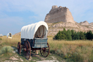
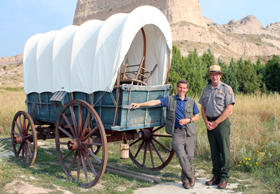
Kearney to Scottsbluff 4 hours 15 mins (I/S 80 west to Ogallala; 26 north and west to Bridgeport to Chimney Rock to Scottsbluff)
- Jail Rock and Courthouse Rock 10 minutes south of Bridgeport. Jail Rock and Courthouse Rock - Two famous landmarks familiar to the pioneers are a short distance south of the North Platte River and easily visible to travelers driving along U.S. Highway 26.
- Chimney Rock The most famous of the trail’s landmarks has suffered erosion over the years and, as a result, is not quite the majestic formation observed by the pioneers, but it is difficult not to experience a thrill when it first comes into sight. Highway 26 is on the south side of the river and passes relatively close to Chimney Rock that is accessible by vehicle.
- Scottsbluff
- Overnight: Barn Anew Bed & Breakfast, 170549 County Road L, Mitchell, Nebraska 69357 Phone: 308.632.8647
Scotts Bluff National Monument
- Early wagon trains skirted the imposing bluff by looping south through Robidoux Pass. Following the opening of Mitchell Pass in 1850, wagons moved single-file and cut deep ruts that remain visible to today’s visitors. Scotts Bluff National Monument preserves the ruts and offers an excellent visitor center that interprets the trail and the pass used by the pioneers. Visitors can walk along the wagon ruts just west of the visitor center. Replica wagons are on the site. A paved road leads to the top of the bluff where outstanding views are available.
Scottsbluff Nebraska to Mount Rushmore, South Dakota 3 hours 15 mins (North on Hwy 71 to Crawford; East on Hwy 20, north on Hwy 385 into South Dakota and through Hot Springs, up through Wind Cave National Park, for bison and other wildlife), into Custer City, then north again just a few miles to Crazy Horse Memorial for a quick drive by. From here continue north on Hwy 385, then take Hwy 244 to Mount Rushmore.)
- Mount Rushmore: iconic American sight carved into a mountainside
Mount Rushmore to Cody WY 6 hours 15 mins (Hwy 16 up to Rapid City to I-90 west to Ranchester WY; US14 to Cody across Bighorn National Forest)
- Cody, Wyoming
- Overnight: Garden Loft Apartment, Chamberlin Inn, 1032 12 Street, Cody, WY 82414 307-587-0202
Cody to Yellowstone National Park 2 hours (highway 14/16/20 west all the way)
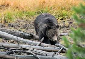
- Yellowstone National Park - Yellowstone National Park is a nearly 3,500-sq.-mile wilderness recreation area atop a volcanic hot spot. Mostly in Wyoming, the park spreads into parts of Montana and Idaho too. Yellowstone features dramatic canyons, alpine rivers, lush forests, hot springs and gushing geysers, including its most famous, Old Faithful. It's also home to hundreds of animal species, including bears, wolves, bison, elk and antelope.
Yellowstone to Jackson WY 3 hours (Highway 287 south to Moran, then 89/191/26 south to Jackson)
- Grand Teton National Park - At approximately; 1,300 km2, the park includes the major peaks of the 64 km Teton Range as well as most of the northern sections of the valley known as Jackson Hole. It is only 16 km south of Yellowstone National Park, to which it is connected by the National Park Service-managed John D. Rockefeller, Jr. Memorial Parkway. Along with surrounding National Forests, these three protected areas constitute the almost 7,300,000 ha Greater Yellowstone Ecosystem, one of the largest intact mid-latitude temperate ecosystems in the world.
- Jackson Hole, Wyoming
- Overnight: Hampton Inn Jackson Hole, 350 S Hwy 89, WY 83002
Jackson WY to Montpellier, ID 2 hours (South on 189; 89 south to Montpellier)
- Montpellier: The National Oregon/California Trail Center, Montpellier
Montpellier to Soda Springs 30 mins (Highway 30 to Soda Springs and Geyser Park)
- Soda Springs The captive geyser erupts on the hour until 10:00pm.
Soda Springs to Lava Hot Springs 20 mins (Highway 30 to Lava Hot Springs)
- Lava Hot Springs: a soothing soak at the Lava Hot Springs Foundation Hot Pools
Lava Hot Springs to Massacre Rocks State Park 1 hour (Highway 30 to I-15 North toward Pocatello and I-86 West)
- Massacre Rocks State Park - site of a famous incident on the Oregon Trail and a rock on which are carved many of the names of the early Pioneers.
Massacre Rocks State Park to Twin Falls 1 Hour 10 mins (Hansen Exit 182 to leave the interstate for Highway 50 then Highway 30 to Twin Falls.)
- Twin Falls: Shoshone Falls. Turn north on N. 3300E Road (Champlin Rd.) and follow the road into the canyon to the falls. Often referred to as the “Niagara of the West”, the waters of the Snake River cascade 212 feet (64.7m) down over the 900 ft. (274m) wide canyon rim to the river below, making Shoshone Falls 36 ft. (10.97m) higher than its majestic sister in upstate New York.
- Travel into Twin Falls on Falls Ave. to Blue Lakes Blvd. N. to the Buzz Langdon Visitors Center near the Perrine Bridge – a great location to watch BASE jumpers. The Perrine Bridge is the only manmade structure in the U.S. where BASE jumping is allowed year-round without a permit and is a popular destination for BASE jumping enthusiasts from around the world. This spectacular bridge spans the majestic Snake River Canyon on the northern edge of Twin Falls. It is 1,500 feet long and 486 feet above the Snake River.
Twin Falls to Glenns Ferry 1 hour (I-84 West)
- Glenns Ferry: Three Island Crossing State Park – where the Native Americans assisted the Oregon Trail travelers in crossing the mighty Snake River. Take Exit 121 and follow the signs to the state park.
Glenns Ferry to Boise 1 hour 10 mins (Drive through Glenns Ferry, return to I-84 West and continue to Boise)
- Boise, Idaho
- Oregon Trail wagon ruts and wagon ramp cut into cliffs
- Overnight: Red Lion Hotel, Boise ID: 1800 Fairview Ave, Boise, ID 83702
Boise to Baker City Oregon 2 hours
- Baker City: National Historic Oregon Trail Interpretative Centre, 22267 OR-86, Baker City, OR 97814 (541) 523-1843 www.blm.gov/or/oregontrail The National Historic Oregon Trail Interpretive Center brings to life the Oregon Trail experience through living history demonstrations, interpretive programs, exhibitions, and special events. Oregon Trail ruts carved by pioneer wagons are located onsite and are featured in a four mile interpretive hiking trail system. Trails and picnic areas offer scenic vistas of the Blue Mountains, the Wallowa Mountains, and Baker Valley.
Baker City to Columbia River Valley, Mount Hood 5 hours
- Tamástslikt Cultural Institute, 47106 Wildhorse Blvd, Pendleton, Oregon 97801 Immerse yourself in the history, culture and hospitality of the people who have lived on this land for more than 10,000 years. Come to Tamástslikt Cultural Institute and experience the storied past, rich present and bright future of the local tribes through interactive exhibits, special events and a Living Culture Village. More than just a museum, Tamástslikt celebrates the traditions of Cayuse, Umatilla and Walla Walla Tribes. With dramatic exhibits, renowned artwork and interesting events year-round. Tamástslikt Cultural Institute offers a 10,000-year voyage in a single afternoon. http://www.tamastslikt.org
- Overnight: Columbia Gorge Hotel, 4000 Westcliff Dr, Hood River, OR 97031 tel: 541-386-5566 www.columbiagorgehotel.com The Columbia Gorge Hotel is a historic landmark in the Columbia River Gorge.
Continue West through the Columbia River Gorge.
- Take the Historic Columbia River Highway and follow the old highway past scenic vistas and rushing waterfalls – the best way to experience the Columbia River Gorge. This drive, with stops in the Gorge will take 2-2.5 hours until you reach the outskirts of Portland.
- The Columbia River Gorge National Scenic Area offers 292,500 acres of unparalleled scenery and outdoor recreation options. A leisurely drive on the Historic Columbia River Highway is a popular way to experience the gorge. Completed in 1922 the road is the oldest national scenic highway in the nation.
- Driving along the Historic Columbia River Highway, pass several waterfalls. Continue east to Horsetail Falls, and take the 15 minute hike (uphill at the start) to Upper Horsetail Falls (also known as Ponytail Falls), where you can walk behind the waterfalls.
- Take the short walk to Multnomah Falls. Plummeting 620 feet (189 m) from its origins on Larch Mountain, Multnomah Falls is the second highest year-round waterfall in the United States. Nearly two million visitors a year come to see this ancient waterfall, making it Oregon’s number one public destination. Fed by underground springs from Larch Mountain, the flow over the falls varies but is highest during winter and spring.
Continue on Highway 30 through Portland all the way northwest to Astoria
- Astoria: Lewis and Clark National Historic Park 92343 Fort Clatsop Rd, Astoria, Oregon 97103 (503) 861-2471 www.nps.gov/lewi/ Explore the timeless rainforests and majestic coastal vistas. Discover the rich heritage of the Native people. Unfold the dramatic stories of America's most famous explorers. The park encompasses sites along the Columbia River and the Pacific Coast. Follow in the footsteps of the explorers and have an adventure in history. Step back in time to discover what life was like for the Lewis and Clark Expedition during their 1805-06 winter stay at Fort Clatsop. There are nature trails, forest and river exploration.
Astoria to Canon Beach 45 mins
- Canon Beach: The end point for the Oregon Trail trip westwards is the sleepy coastal town of Cannon Beach. Grab a warm cup of coffee at the Sleepy Monk and a walk through the sand out to Haystack Rock located in the middle of the Pacific Ocean surf.
Canon Beach to Portland 1 hour 30 mins (West on Highway 26)
- Overnight: Embassy Suites Portland Airport, 7900 North East 82nd Street, Portland OR 97220 503-460-3000
- Return rental car and fly back to Toronto from Portland International
Total 48 hours driving
 Established in 1872, Yellowstone National Park in Wyoming is the world’s oldest and perhaps most famous national park, known worldwide for its geysers and geothermal pools. The largest of America’s national parks outside Alaska, Yellowstone crosses volcanic plateaus and heavily forested peaks, containing 2.2 million acres of steaming hot springs, crystalline lakes and thundering waterfalls. Established in 1872, Yellowstone National Park in Wyoming is the world’s oldest and perhaps most famous national park, known worldwide for its geysers and geothermal pools. The largest of America’s national parks outside Alaska, Yellowstone crosses volcanic plateaus and heavily forested peaks, containing 2.2 million acres of steaming hot springs, crystalline lakes and thundering waterfalls.
Of course, this natural glory is no secret. With over three million visitors a year - the vast majority coming between June and September - the park’s popularity may mean that summertime visitors can see more RV (recreational vehicle) bumpers than buffalo. This doesn’t mean that summer visits to this beloved park aren’t worth it; just come expecting plenty of company.
Geothermal curiosities such as Old Faithful and the Norris Geyser Basin are just the beginning of Yellowstone’s beguilements. The park offers incredible natural diversity and abundant wildlife, together with picture-postcard views. The Grand Canyon of the Yellowstone River, 24 miles long and up to 1,200 feet deep, begins at the river’s thundering 308-foot Lower Falls; bear and bison roam the grassy meadows of the Hayden Valley; elk linger near the hot springs terraces at Mammoth; some 225 bird species flit from spruce to fir; and grey wolves, reintroduced to the park in 1995 after being almost eradicated in the 1930s, hunt in the Lamar Valley.
One highlight of a summer visit may be a stay at the Old Faithful Inn. The huge lodgepole pine edifice, designed in rugged American Craftsman style, is right next to its namesake geyser, which sends a spray of steaming water up to 184 feet into the air every 68 to 98 minutes. The recently renovated 100-year-old inn (possibly the world’s largest log building) set the fashion for all the great lodges of the national park system back in its day. The rooms are somewhat spartan, but take a seat in the inn’s grandly evocative log-and-stone lobby, highlighted by a massive four-sided fireplace rising more than 90 feet; it’s guaranteed to make your heart soar.
In the off-season, Yellowstone seems less like a park and more like nature itself. This is when you realise that the real tension here is not about traffic or crowded campsites, but about what’s brewing beneath the earth’s crust. The park’s 150 geysers and the bubbling mud pools, hissing fumaroles and hot springs act as pressure valves, releasing the heat and steam that build up below the ground. Together, they make up the world’s largest geothermal system (75 per cent of the earth’s geysers are found here in Yellowstone), remnants of a tumultuous volcanic past that Rudyard Kipling described as “the uplands of Hell”.
Winter is the serene season in Yellowstone. Only one entrance, from Gardiner, Montana, remains open to vehicles as far as Mammoth Hot Springs, while the park’s other entrances are open to cross-country skiers and snowshoers, as well as to guided tours on snowmobiles and snowcoaches (van-like vehicles with ski runners and snowmobile-like treads). Snowcoaches also run deep into the park to Old Faithful Snow Lodge. Completed in 1999, this is the newest Yellowstone lodge, and with winter accommodation and dining, it’s the perfect base for snowshoeing or cross-country skiing.
Only one per cent of visitors to Yellowstone venture beyond five kilometers of the park’s paved highways, regardless of the season. Yellowstone is a big place, so that a quiet communion with nature is never more than a short walk away.
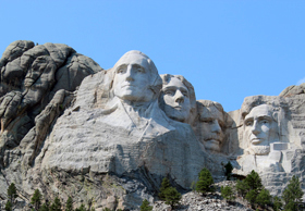 For the generation that saw it born, Mount Rushmore in South Dakota was the symbol of American optimism after the triumph of WWI. For many who grew up in the 1950s and ’60s, it became a symbol of the family road trip. And for American Indians of any generation, it’s a complicated symbol of broken treaties and loss. For the generation that saw it born, Mount Rushmore in South Dakota was the symbol of American optimism after the triumph of WWI. For many who grew up in the 1950s and ’60s, it became a symbol of the family road trip. And for American Indians of any generation, it’s a complicated symbol of broken treaties and loss.
Conceived in 1924 by Danish-American sculptor Gutzon Borglum, the great sculptures on Rushmore were to be a ‘Shrine of Democracy’ that would use the presidents’ images to trace the country’s history, from its birth (Washington) through to its early growth (Jefferson), preservation (Lincoln) and robust development in the 20th century (Teddy Roosevelt). Work on the monument began on October 4, 1927, and ended 14 years later, on October 31, 1941. When the granite dust cleared, Rushmore had been transformed forever, with four enormous faces, six storeys high, peering into the Black Hills.
Though America hailed Borglum’s great achievement (completed by the sculptor’s son, Lincoln, after his father’s death), the work was a slap in the face to South Dakota’s Lakota people, to whom Paha Sapa (the Black Hills) was a sacred place that figured prominently in their creation stories. An 1868 treaty had given the deeds of the land to the Sioux ‘in perpetuity’, but their ownership lasted only six years. When gold was discovered in the area, the U.S. government reclaimed the land. In 1876, when the government ordered all Lakota bands on to reservations, the great chiefs Crazy Horse, Sitting Bull and Gall organised a resistance that eventually destroyed the Seventh Cavalry in General George Custer’s Last Stand at the Little Bighorn. But the Sioux’s victory was short-lived; in less than two years Crazy Horse was dead, and their fate was sealed.
Want to know more about the destination? Check out Chris' Travel Notes!
Chris writes extensive Travel Notes for each show that will help you plan your next trip. Find out more about the Destination; Climate; Getting Around; Accommodation; Kids to Seniors; History; Sports and Activities; Attractions; Culture; Cuisine; Special Deals and where to go to get even more information!
Click on the Travel Notes icon to download a pdf file that you can read, print out and even take with you on your travels! |
|
|